19th Century Atlases
![Ch'onha chido [Atlas of all under Heaven]](/images/atlases/topimages/250px/1820_korea.jpg)
- Title Ch'onha chido [Atlas of all under Heaven]
- Author Anonymous
- Year 1820 (early 19th century)
- Publisher
- Size 44.2 x 48.0 cm
11 manuscript maps from a traditional Korean manuscript atlas from the early 19th century. Mounted in a double concertina format during the 1970s by a very skillful Korean bookbinder. Covered with Korean fabric.
Ch’onha chido (Atlas of the world) is a traditional Korean atlas produced between mid 18th and early 19th century. With a China-centered world map (Chonha-Do), a map of Korea, 7 maps of the Korean provinces, a map of China and a map of Japan. Read more →
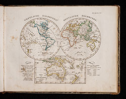
- Title Stieler's Schul-Atlas über alle Theile der Erde nach dem neuesten Zustande, und über das Weltgebäude. Nach Stieler's Hand-Atlas verkleinert. Zwanzigste verbesserte und vermehrte Auflage.
- Author Stieler, Adolf; Reichard, Gottlieb; Bär, Johann Christoph
- Year 1840
- Publisher Justus Perthes, Gotha
- Size Large oblong 8to, 24.5 x 32.5 cm
In the middle of 1817 under the direction of Wilhelm Perthes (1793-1853), the first delivery of the Hand-Atlas über alle Theile der Erde, nach dem neuesten Zustande, und über das Weltgebäude, nebst einem geogr. Texte took place. After three further deliveries, 50 maps were available in March 1823, which were later referred to as the "Original edition". Read more →