18th Century Atlases
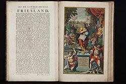
- Title Uitbeelding der heerlijkheit Friesland; zoo in 't algemeen, als in haare XXX bijzondere grietenijen; door Dr. Bern. Schotanus a Sterringa... Uitgegeeven door Francois Halma, 1718.
- Author Schotanus van Sterringa, Bernhard; Halma, François; Alting, Menso; de Broen, Gerrit; Hilarides, Johannes;
- Year 1718
- Publisher François Halma, Leeuwarden
- Size Imperial Folio, 57.0 x 37.5 cm
Second and enlarged edition of the first atlas of the Dutch province of Friesland, including 30 detail maps of the entire provinces of Friesland, an overview map of Friesland and 8 historical maps of the Netherlands.
The first edition was produced by Bernard Schotanus in 1698 after he received an order from the Gedeputeerde Staten for a new mapping out of the Grietenijen. Read more →
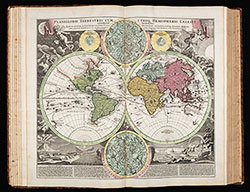
- Title Atlas Novus Terrarum Orbis Imperia, Regna et Status exactis Tabulis Geographice demonstrans / Novus Atlas c. tabularum, cosmo-geographicarum Homannianarum.
- Author Homann, Johann Baptist; Homann, Johann Christoph; Homann Heirs
- Year 1731
- Publisher Homann Heirs, Nürnberg
- Size Imperial Folio, 56.5 x 37.0 cm
Monumental atlas of the world with 100 maps by Johann Baptist Homann. All maps coloured by an 18th-century hand.
Germany's most famous 18th-century world atlas by J. B. Homann, the founder of the famous Nuremberg map publishing house. Homann's Grosser Atlas was first published in 1716. When Homann died in 1724, the business was continued by his son Johann Christoph. Read more →
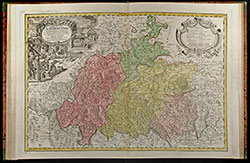
- Title Atlas Silesiae Id Est Ducatus Silesiae Generaliter Quatuor Mappis Nec Non Specialiter XVI Mappis Tot Principatus Repraesentantibus Geographice Exhibitus
- Author Homann, Johann Baptist; Homann Heirs
- Year 1750
- Publisher Homann Heirs, Nürnberg
- Size Imperial Folio, 64.0 x 48.0 cm
Large special atlas of Silesia by the Homann publishing house.
During the reign of Charles VI., the engineer Johann Wolfgang Wieland was assigned to surveying Silesia. After his death in 1736, Homann heirs in Nuremberg have been commissioned with the publication of the most detailed maps of Silesia at the time.
The atlas consists of 4 overview map with engraved text in margin and 16 large scale detailed maps with decorative cartouches. Read more →
![Ch'onha chido [Atlas of all under Heaven]](/images/atlases/topimages/250px/1750_korea.jpg)
- Title Ch'onha chido [Atlas of all under Heaven]
- Author Anonymous
- Year 1750 (mid 18th century)
- Publisher
- Size 43.5 x 41.0 cm
9 woodblock maps from a traditional Korean woodblock atlas, printed mid 18th century. Mounted in a double concertina format during the 1970s by a very skillful Korean bookbinder. Covered with Korean fabric.
Ch’onha chido (Atlas of the world) is a traditional Korean atlas produced between mid 18th and early 19th century. With a map of China and Korea and 8 maps of the provinces of Korea. Read more →
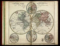
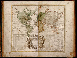
- Title Atlas geographicus omnes orbis terrarum regiones in XLI tabulis ... / Atlas géographique représentant en XLI cartes toutes les regions de la terre ...
- Author Euler, Leonhard
- Year 1753
- Publisher Michaelis, Berlin
- Size large 4to, 35.5 x 23.0 cm
First edition of the rare atlas by Leonhard Euler. The atlas was created under the auspices of the Royal Prussian Academy of Sciences in Berlin by the famous mathematician Leonhard Euler, intended for use in schools. As such, only very few copies have survived, especially in excellent conditions. The second edition was published in 1760 with 44 maps, followed by the third unaltered edition in 1777, which was printed until 1784. Read more →
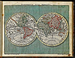
- Title Geographischer Atlas bestehend in 44 Land-Charten, worauf alle Theile des Erd-Creyses vorgestellet werden. Auf Befehl der Königlichen Academie der Wissenschaften nach den bischer herausgekommenen besten Charten beschrieben, und insbesondere zum Gebrauch der Jugend in den Schulen herausgegeben.
- Author Euler, Leonhard
- Year 1760
- Publisher Christian Ludewig Kunst, Berlin
- Size large 4to, 37.0 x 24.0 cm
Rare school atlas by the famous mathematican Leonhard Euler. It was the most successful project of the Royal Academy of Sciences in Berlin. First edition was published in 1753, titled Atlas geographicus omnes orbis terrarum regiones in XLI tabulis with a preamble of L. Euler. This second edition was published 1760, followed by third unchanged edition in 1777 until 1784. Read more →
- Title Atlas Geographicus portatilis XXIX mappis orbis habitabilis regna exhibens ... Kurzgefasste Geographie, in sich haltend einen aneinander hangenden Entwurf aller Theile des bewohnten Erdbodens, nebst compendieusen Land-Charten, welche einen kleinen Sack-Atlas ausmachen.
- Author Lotter, Tobias Conrad
- Year 1762
- Publisher Tobias Lobeck; Joh. Michael Wagner, Augsburg
- Size Oblong small 8vo, 11.5 x 14.5 cm
Pocket atlas of Tobias Conrad Lotter. Bound with "Kurzgefasste Geographie" of Tobias Lobeck. With an engraved allegorical title-page and frontispiece by Tobias Lobeck after G. Eichler, 1 world map, 1 celestial map, 37 european maps including 14 maps of Germany not mentioned in index. All fine engraved with original hand-colour. Read more →
![Ch'onha chido [Atlas of all under Heaven]](/images/atlases/topimages/250px/1780_korea.jpg)
- Title Ch'onha chido [Atlas of all under Heaven]
- Author Anonymous
- Year 1780 (late 18th century)
- Publisher
- Size 41.5 x 40.5 cm
12 manuscript maps from a traditional Korean manuscript atlas from the late 18th century. Mounted in a double concertina format during the 1970s by a very skillful Korean bookbinder. Covered with Korean fabric.
Ch’onha chido (Atlas of the world) is a traditional Korean atlas produced between mid 18th and early 19th century. With a China-centered world map (Chonha-Do), a map of China with Korea, two maps of the Ryukyu Islands and 8 maps of the Korean provinces. Read more →
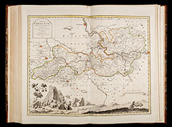
- Title Atlas Saxonicus novus, enthaltend die sieben Kreise des Kuhrfürstenthums Sachsen.
- Author Schenk, Pieter; Zürner, Adam Friedrich
- Year 1781
- Publisher P. Schenk & Sohn; Amsterdam, Leipzig, Dresden
- Size Large Folio, 55.0 x 36.5 cm
The Atlas Saxonicus novus (New Saxony Atlas), also known as the Schenkscher Atlas, is an important central German atlas from the 18th century.
After the death of the geographer Adam Friedrich Zürner in 1742, some of the maps of the Electorate of Saxony drawn by him were corrected by the geographer Paul Trenckmann and his son Johann Paul Trenckmann. Read more →