16th Century Atlases
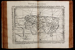
- Title Claudii Ptolemaei Alexandrini Geographicae Enarrationis, Libri Octo ... Prostant Lugduni apud Hugonem a Porta. M. D. XLI.
- Author Ptolemaeus, Claudius; Fries, Laurent; Servetus, Michael
- Year 1541
- Publisher Trechsel, Gaspar; Vienne, Dauphine; sold by Hughes de la Porte in Lyon
- Size Folio, 40.5 x 29.0 cm
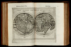
Renaissance atlas with woodcut maps, based on the so-called first modern atlas of Martin Waldseemüller. For the first time, a significant number of maps with the latest geographical surveys and observations are added to the traditional Ptolemy maps. The traditional maps can be found in early manuscripts and from 1477 onwards also in printed versions of the Geographia by Claudius Ptolemy, based on written records from the years around 150 AC. Read more →
- Title Geographiae Claudii Ptolemaei Alexandrini, Philosophi ac Mathematici praestantissimi, Libri VIII...
- Author Ptolemaeus, Claudius; Münster, Sebastian; Wolffhart, Konrad; Pirckheimer, Willibald
- Year 1552
- Publisher Petri, Henrich; Basel
- Size Large 4to, 32.0 x 23.5 cm
Sebastian Münster's Geographia Universalis, printed in Basel by Henrich Petri in 1552. With 54 double page woodcut maps.
This is the 4th edition of Münster's Geographia, enhanced with a treatise by Konrad Wolffhart (Conradus Lycosthenus) and an elaborate index divided into two parts, referring now to the ancient and the modern maps. It is the last edition of the Geographia published during Münster's lifetime and the first with a royal privilege from the king of France. Read more →
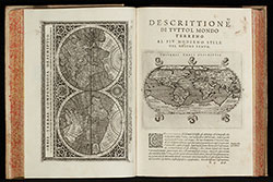
- Title La Geografia di Claudio Tolomeo Alessandrino, Nuovamente tradotta di Greco in Italiano da Ieronimo Ruscelli.
- Author Ruscelli, Girolamo
- Year 1564
- Publisher Giordano Ziletti, Venice
- Size 4to, 24.5 x 17.5 cm
Third edition of Ruscelli's translation of Ptolemy's Geografia and first edition published by G. Ziletti in 1564. The first two Ruscelli editions have been published 1561 and 1562 by V. Valgrisi. The maps of the first five editions of Ruscelli are printed from the same copper plates of Valgrisi. They are based on the maps of Jacopo Gastaldi which appeared in Mattioli's 1548 translation of Ptolemy's Geographia. Read more →
![Parergon, sive Veteris Geographiae aliquot Tabulae. [Bound with:] Nomenclator Ptolemaicus.](/images/atlases/topimages/250px/1595_ortelius_parergon.jpg)
- Title Parergon, sive Veteris Geographiae aliquot Tabulae. [Bound with:] Nomenclator Ptolemaicus.
- Author Ortelius, Abraham
- Year 1595
- Publisher Christopher, Plantin; Antwerp
- Size Folio, 44.3 x 28.5 cm
An atlas of the ancient world by Abraham Ortelius. The Parergon maps began appearing as supplements within Ortelius main work the Theatrum Orbis Terrarum in 1579 with 3 maps. During the following years, more map were completed and the Parergon became an atlas in its own right. The present edition of 1595 is usually bound with the 1595 Latin edition of the Theatrum Orbis Terrarum. Read more →
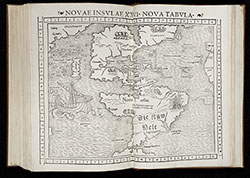
- Title Geografia cioe Descrittione Universale della Terra ... Nuovamente ... Rincontrati, & Corretti ... Gio. Ant. Magini ... Opera ... Tradotta dal R.D. Leonardo Cernoti ...
- Author Magini, Giovanni Antonio; Cernoti, Leonardo
- Year 1597
- Publisher Giovanni Battista Galignani and Giorgio Galignani, Venice
- Size 4to, 30.5 x 22.0 cm
The first edition of Leonardo Cernoti's Italian translation of Ptolemy's Geografia based on the 1596 Latin edition of Magini published by G. B. Galignani & G. Galignani in 1597-98. The maps are attributed to Girolamo Porro and have been also used in Magini's translation of 1596.
Illustrated with two engraved title vignettes, one full page and 63 half page engraved maps and several woodcuts in the text. Read more →
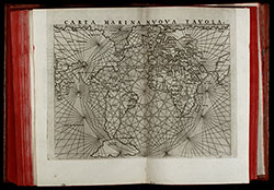
- Title Geografia di Claudio Tolomeo Alessandrino Tradotta di Greco nell'Idioma Volgare Italiano da Girolamo Ruscelli
- Author Ruscelli, Girolamo; Rosaccio, Giuseppe
- Year 1598
- Publisher M. Sessa Heirs, Venice
- Size 4to, 25.0 x 18.5 cm
Sixth edition of Ruscelli's translation of Ptolemy's Geografia edited and extended by Giuseppe Rosaccio published by the heirs of M. Sessa in 1598 and 1599.
Illustrated with 69 double page engraved maps and several woodcuts in the text. Whereof 27 Ptolemy maps and 42 'modern' map, including 4 world maps (one Ptolemy /Shirley 133, three modern /Shirley 110, 111, 217), 7 maps of America (Western Hemisphere, South America, Mexico with Florida, Brazil, east coast of North America, Haiti, Cuba), 28 European maps (including the North-Atlantic map with parts of Labrador), 10 maps of Africa and 20 maps of Asia. Read more →