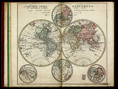
First edition of the rare atlas by Leonhard Euler. The atlas was created under the auspices of the Royal Prussian Academy of Sciences in Berlin by the famous mathematician Leonhard Euler, intended for use in schools. As such, only very few copies have survived, especially in excellent conditions. The second edition was published in 1760 with 44 maps, followed by the third unaltered edition in 1777, which was printed until 1784.
The maps, mostly based on works of Johann Christoph Rhode were mostly engraved by Nicolaus Friedrich Sauerbrey. This edition includes a title page, a 10-page preface by Leonhard Euler in Latin and French, 41 double-page engraved maps as mentioned in the title and preface, plus 4 additional maps. Highlights are 4 maps of the world (one in two sheets) and the 4-sheet map of America. Each map is old coloured by a contemporary hand and has a stamp of the Royal Prussian Academy of Sciences.